Stourpaine is our village in the Blackmore Vale in North Dorset, England, on the River Stour

Home | Environment | Community | Businesses | News | Gallery | Contacts | Blog | About ||| < Previous | Next > |||
© G McCavitt


Manor House Ancient Monument
Manor House Ancient Monument
Earthworks on Site of Manor House
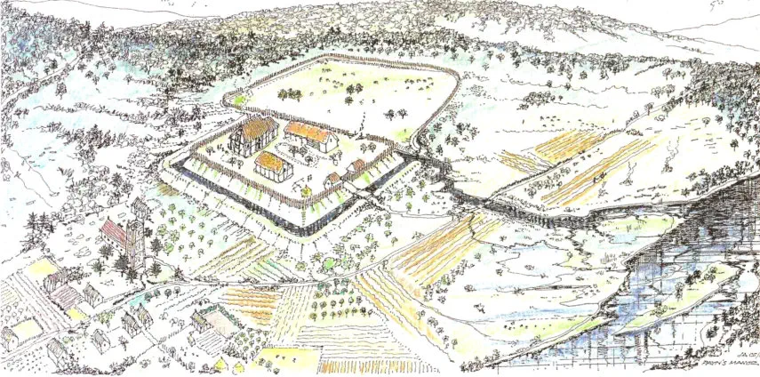
The conjectural view of Stourpaine is based on what remains of its ancient heart. A manor house sits within its defensive banks and ditches and the adjacent church shows off its new tower. The river Stour is closer than now and unrestrained, flooding adjacent meadows and filling the ditch of the manor house when in flood. The surrounding forests are giving way to felling and burning, and newly fertilized soil is being cultivated for the first time. Beyond the palisaded manor is a further enclosure for animals. Around the church the street plan of Stourpaine is beginning to emerge. The houses, like the manor, are of timber frame construction, or of cob, and thatched with long straw. Only the church has dressed stone and a tile roof. Above the manor, to the left of the picture, is a small road which would one day become the A350. Below the manor, in the nineteenth Century, the great embankment of the new railway would sever the manor and river for ever. At a time when new development is closing in around the historic core of the village it is important to know and respect its past the church and the manor house, now only recognisable by its earthworks in the field, have had an important link since the Norman conquest, and probably before. Knowing our past is the first step in protecting it. John Ashurst RIBA and John Stitt - February 2004

STOURPAINE (9)
HBMC RECORDS OFFICE
SCHEDULED ANCIENT MONUMENTS RECORD
Dorset (SEMESTERS 9-11)
3-SEP-1987
-----------------------------------------------------------------------------------------------
COUNTY NO. Dorset 241
SAM PRN 30501
DISTRICT/BOROUGH North Dorset
PARISH Stourpaine
NGR ST859093
HT OD (METRES) 40
FILE
AA 61623/1
SITE NAME
Earthworks on Site of Manor House
DESCRIPTION
A
square
moat
with
quite
considerable
inner
bank,
especially
in
SE
corner,
and
larger
less
protected
enclosure
to
S,
overlying remains of earlier circular moat with inner bank lying mostly in S enclosure. {1}
Small
square
entrenchment,
sides
30yds,
perhaps
site
of
manor
house,
though
local
tradition
alleges
it
be
an
old
mill
bay. Small circular enclosure said to be a cockpit. {2}
Many
surface
irregularities
like
minor
depressions,
banks,
scarps,
some
vague
platforms
(probably
building
sites).
Site
of manor house is square level platform with no sign of masonry. Moat is deeper on E than W because of W
facing
slope.
Moat
much
damaged,
7m
wide,
l.5-3m
deep,
upcast
used
to
form
inner
bank
7m
wide
and
1.8m
high.
Immediately
S
of
the
moat
is
oval
earthwork
formed
by
bank
7m
wide,
0.5m
high,
and
outer
ditch
6m
wide
and
0.3m
deep.
This,
with
enclosure
bank
to
E
and
bank
and
ditch
forming
S
angle
of
area
are
all
doubtless
Medieval
occupation.
Relative dates of moat and oval earthwork not determined. {3}
Moat
(class
A2{b})
occupies
N
third
of
site.
N
side
and
N
third
of
E
side
almost
completely
filled
in,
only
marked
by
a
scarp,
3ft
high
along
edges
of
island.
Rest
of
E
side
and
all
of
S
and
W
sides
bounded
by
deep
wide
ditch,
now
dry
but
once
wet.
Pond
covers
NW
corner.
External
bank
lft
high
along
W
side.
Modern
spoil
heap
in
SE
corner
of
interior.
No
entrance
or
causeway
visible.
Adjoining
S
side
of
moat
are
remains
of
rectangular
banked
enclosure
of
2
acres,
bounded
on
E
by
low
spread
bank
and
on
S
by
bank
3ft
high
with
external
ditch.
1st
edition
of
OS
25"
map
shows
50Yds
of
bank
at
S
end
of
W
side:
this
was
perhaps
destroyed
when
railway
was
built
1863.
Lying
against
moat
is
roughly
circular
earthwork
with
internal
diameter
100ft,
bounded
by
low
bank
and
external
ditch.
Gap
in
NW
part
of
bank. This certainly later than moat. {4}
Morphology
and
dimensions
as
{4},
W
part
of
site
under
cultivation
but
remainder
grassland,
good
condition
apart
from entrance to farm. Inner bank on E side looks artificially high, possibly as a result of rubbish dumping.
Ditch full of weeds. {5}
SlTE TYPE
Moat
PERIOD
Medieval
SPEC. PERIOD
-
FORM
Earthwork
SITE TYPE
Enclosure
PERIOD
Medieval
SPEC. PERIOD
-
FORM
Earthwork
PROPORTION SCHED. 1 SURVIVAL WITHIN AREA 5 CONDITION B AREA ??
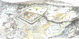
Zoom-in view of the Earthworks
- drawing Ashhurst